
Site Development Infrastructure Planners Surveyors
Surveying + SUE
Our Survey Department offers a full spectrum of land surveying and mapping capabilities for land development, environmental, transportation and infrastructure projects including laser scanning, GPS in addition to conventional surveying/techniques.

RDU AIRPORT
RALEIGH/DURHAM AIRPORT TAXIWAY F REHABILITATION - Provided design topographical and location survey for pavement rehabilitation at the north and south ends of Taxiway F consisting of approximately 37 acres. Services included locating and surveying underground utilities and pavement markings within the survey boundary.

CITY OF GREENSBORO
CITY OF GREENSBORO DOWNTOWN GREENWAY PHASE IV SURVEY - Provided surveying services for the design of a new 3.5-mile greenway. Survey services included providing supplemental surveying for the location of above-ground planimetric, underground utilities and above ground features within the 50’ corridor. The survey also included establishing control coordinates for aerial surveying.
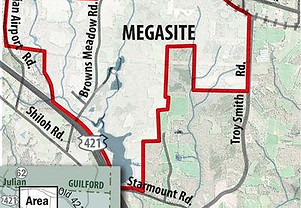
RANDOLPH COUNTY/CITY OF GREENSBORO
RANDOLPH COUNTY/GREENSBORO MEGA SITE SURVEY - Conducted property research on approximately 150 properties to determine owners affected by proposed water main extension. Provided location survey of the underground utilities on both sides of NC 62. Provided boundary survey to identify the location of all property corners needed to establish existing property lines, existing rights-of-way and existing easements that would be part of any proposed easements or rights-of-way. Also, located any property lines establishing a roadway right-of-way within any proposed improvements.